Dupnitsa—Strandzha’s underground wonder and the only tourist cave in Eastern Thrace
Dupnitsa (Turkish: Dupnisa Mağarası, Bulgarian: Dupnitsa) is one of the most amazing natural attractions in northwestern Turkey, hidden in the dense forests of the Strandzha mountain range right on the border with Bulgaria. This karst system in the province of Kırklareli consists of three interconnected caves on two levels and stretches a total of 3,200 meters. The name Dupnitsa comes from the Bulgarian language and derives from the word “dupka” — “hole,” “pothole.” The cave has been open to visitors since 2003 and is currently the only equipped show cave in all of Eastern Thrace. Here, travelers will find a rare combination of 180-million-year-old geology, underground rivers, massive stalactites, and colonies of bats comprising eleven species.
History and Origin of Dupnitsa
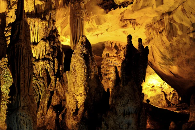
The geological history of the cave stretches back to a time that humanity can only judge by the layers of rock. The Dupnitsa system was formed as a result of the erosion of marble strata during the Toarcian stage of the Early Jurassic period—about 180 million years ago. Over millions of years, water seeping through cracks in the Strandzha marble dissolved the rock and gradually carved out a complex three-level labyrinth of chambers, galleries, and underground rivers. It was then that the future massive dripstone formations began to take shape: stalactites, stalagmites, stalagnates, wall draperies, and the famous boxworks—openwork crystalline structures on the ceilings of the lower chambers.
Human history near the cave is much shorter, but no less interesting. In 1913, the Bulgarian ethnographer Lyubomir Miletich recorded in his notes the existence of a nearby Bulgarian farmstead (chiflik) called Dunnitsa, consisting of fifteen to twenty households. The settlement was located directly south of the current Turkish-Bulgarian border, in close proximity to the cave’s entrance. After the Second Balkan War of 1913, the residents of this hamlet were resettled to Bulgaria, and the settlement was abandoned. Since then, the forest around Dumnitsa has once again become deserted, and the cave itself remained of interest only to shepherds and rare speleological researchers for many decades.
Scientific study of the cave began in the mid-20th century, but truly detailed mapping of its chambers and surveys of its biota were not conducted until the 1990s. In 2001, a large-scale census of bats was conducted: scientists counted approximately 30,000 bats of eight species in the chambers of Dupnitsa. By the time the cave was opened to tourists in 2003—according to other sources, in 2005—the population had grown to an estimated 60,000 individuals of eleven species, making Kyz-Magara one of the largest bat roosts on the entire Balkan Peninsula.
Architecture and What to See
Contrary to the first impression given by its name, Dupnitsa is not a single cave, but an entire underground network of three interconnected chambers located on two levels with an elevation difference of about 60 meters. Only two of the three entrances are open to visitors, covering about 450 meters of the route; however, even this short journey is enough to appreciate the scale of nature’s geological work over time.
Sulu Magara — “Wet” Cave
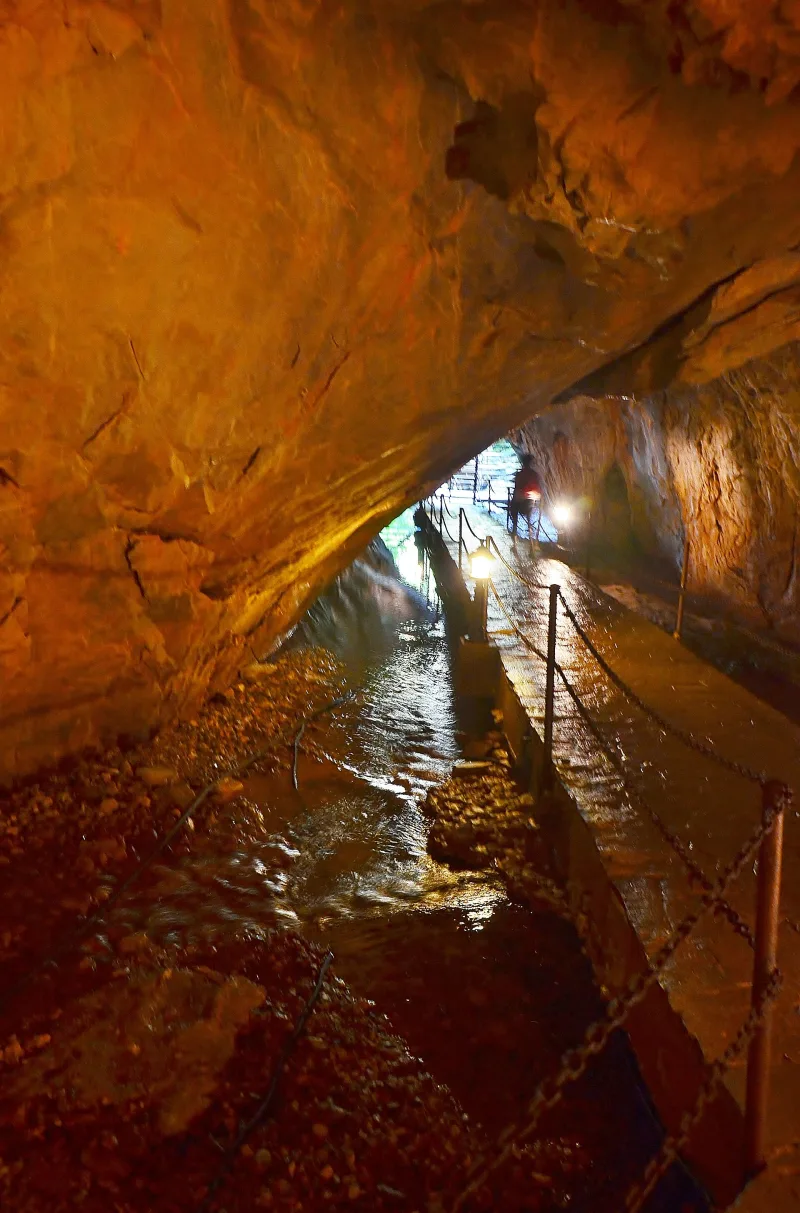
The main tourist entrance leads to Sulu Magara (“Wet Cave”)—the lower level of the system, located 345 meters above sea level. The total length of this cave is 1,977 meters, of which 1,000 meters are filled with water. Underground streams flow along its floor, and dark lakes spread out, with drapery and boxworks hanging over the mirror-like surface. The first 250 meters are open to tourists, equipped with a smooth stone path and metal railings. The sound of falling drops, the echoing footsteps, and sudden cold drafts create the sensation of being immersed in a completely different world—one where water has been shaping its own architecture for centuries. Passing beyond the open section is permitted only to experienced speleologists for research purposes: beyond the 250-meter mark, a true underground river begins, featuring complex siphons and unstable clay collapses, where outsiders have no business being.
Kuru Magara — “Dry” Cave
At the end of the guided route in Sulu Magara, a staircase leads upward—to Kuru Magara, the “Dry Cave.” Its two branches extend 456 and 363 meters; the first 200 meters are open to tourists. Here, the dripstone formations reach colossal sizes—stalactites merge with stalagmites into massive columns, and the walls are covered with stone “curtains” tens of centimeters thick. It is from Kuru Magara that a spring originates, which then feeds the Rezve (Rezovska) River, flowing along the border between Turkey and Bulgaria. The first entrance to Kuru Magar is located 100 meters southeast of the main entrance at Dupnitsa and consists of an almost vertical five-meter shaft; the second entrance is another twelve meters lower and 225 meters further southeast. One of the branches of Kuru Magara is connected to the surface by a narrow chimney—through it, frosty air flows into the cave in winter, causing the stalactites to form a thin crust of frost. Another branch descends to Sulu Magara, linking the three-dimensional underground labyrinth into a single system.
Kyz Magara — “Maiden’s” Cave
The third entrance, Kyz Magara (“Maiden’s Cave”), begins with a steep 60-degree descent and leads into a massive hall measuring 150 by 60 meters. This part of the system is closed to tourists year-round and is considered one of Europe’s most important bat roosts. According to experts, about 60,000 bats of eleven different species live here. In addition to bats, Kyz Magara is home to rare cave butterflies and cave flies—a veritable underground laboratory for biospeleologists.
The Return Journey and Forest Trail
The exit from Kuru Magara is located 61 meters above the entrance to Sulu Magara. From there, a marked forest trail takes visitors back to the start of the route—a leisurely 15-minute walk. This short walk through the beech forest of Strandzha is a special treat: patches of sunlight flicker between the trunks, the air is thick with the scent of pine needles and damp earth, and somewhere in the bushes, deer and wild boars—for which the local biosphere reserve is famous—rustle.
Interesting Facts and Legends
- The name Dupnitsa is directly linked to the Bulgarian word “dupka,” meaning “hole” or “pothole,” and originated long before the Turks arrived in the region—back when the slopes of Strandzha were inhabited by Bulgarian shepherds and charcoal burners.
- In the first four months of 2012 alone, the cave was visited by more than 17,000 local and foreign tourists. In 2013, according to the deputy director of culture and tourism in Kırklareli, the number of visitors reached 120,000—a record for all of Eastern Thrace.
- An underground spring originating deep within Kuru Magara forms the source of the Rezve River (Turk. Rezve Deresi)—the natural border between Turkey and Bulgaria. In other words, a drop falling from the cave’s ceiling can cross the state border within just a few hours.
- Due to the periodic breeding of bats, Dupnitsa is completely closed to tourists from November 15 to May 15. This six-month closure is one of the strictest conservation measures among all developed caves in Turkey.
- Local residents from the village of Sarpdere still call the cave the “brides’ home” and tell the legend of a girl who hid in Kiz Magara from her pursuers—according to legend, the bats themselves protected her from her enemies by blocking the entrance to the chamber with their bodies.
- The cave is the only developed tourist cave in all of Eastern Thrace (the European part of Turkey) and the only one where active underground rivers and massive “dry” stalactite formations are combined in a single route — such a variety of hydrological types within a single system is considered a rarity even for the Balkan karst regions.
How to get there
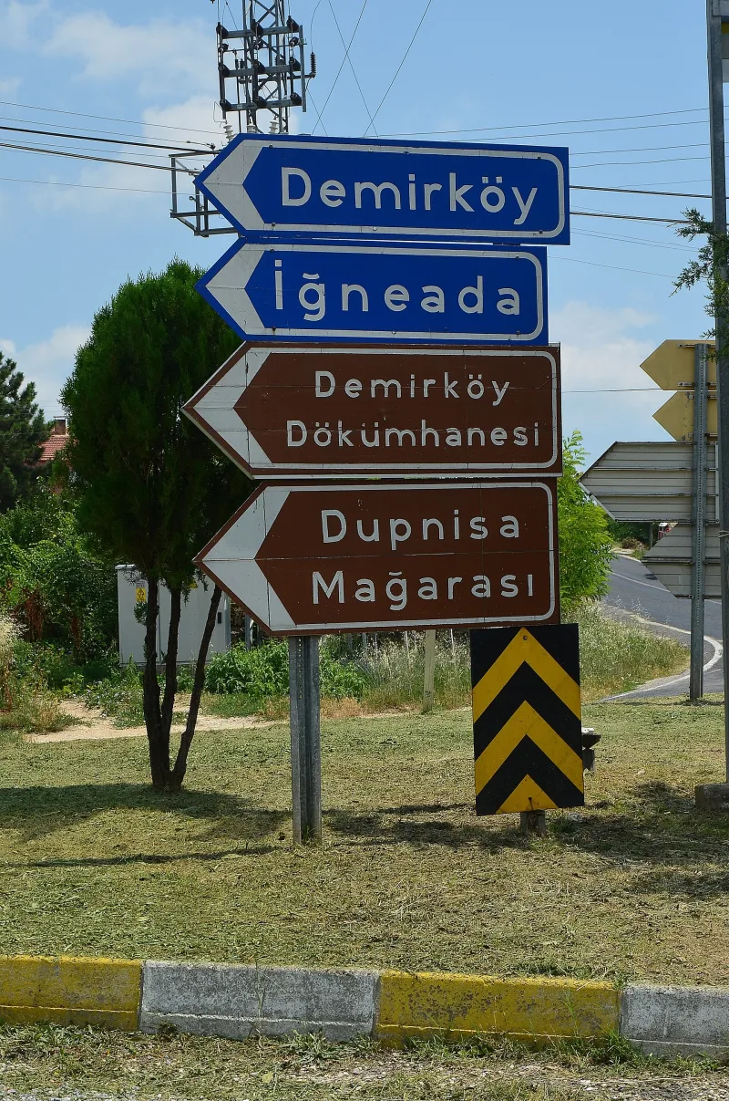
The cave is located deep in the forest on the Strandzha Ridge, 5.5 kilometers southwest of the village of Sarpdere and 25 kilometers southwest of the district center of Demirköy. It is about 58 kilometers from the provincial administrative center, the city of Kırklareli, and approximately 230 kilometers from Istanbul. By car from Istanbul, the journey takes about three hours via Highway D.020 through Vize and then along D.565 to Demirköy, or via State Road D.555 through Kırklareli and Dereköy.
For travelers without a car, the best option is to take a bus from Istanbul to Kırklareli (regular service from the Esenler terminal, about four hours), and from there take a dolmuş or taxi to Demirköy and Sarpdere. The last 5–6 kilometers from Sarpdere to the cave entrance follow a forest dirt road—in dry weather, it is passable for any vehicle, but after rain, it is better to use an SUV. Signs for “Dupnisa Mağarası” can be found along the road from Demirköy. From the north, there are three alternative routes to the cave: Dereköy–Sarpdere, as well as the route via Kırklareli–Uşak–Çukurpınar–Sarpdere. From the south, it is more convenient to take the D.020 Vize–Poyralı road and then the D.565 Poyralı–Demirköy road, and from there, the forest road to Sarpdere, which is well-known to all locals.
Tips for travelers
The main rule of planning is to keep seasonality in mind. The cave is open only from May 15 to November 14; access is closed the rest of the time to protect hibernating and breeding bats. The best time to visit is June and September: the spring dampness has passed, and the autumn downpours that turn the forest road into a mud bath haven’t started yet. In July–August, Strandzha is pleasantly cool, +20…+24 °C, while Istanbul is sweltering in the heat.
Inside the cave, the temperature stays around +10 °C year-round with very high humidity, so be sure to bring a warm sweater or windbreaker and shoes with non-slip soles. The stone paths are constantly damp, sometimes covered with a thin layer of clay, and the railings don’t always provide enough support. You don’t need to bring a flashlight—the route is lit—but a small headlamp will come in handy for examining the details of the stalactite formations. It’s best to leave your camera tripod in the car: the space is narrow, and visitors move in a constant stream.
Allow 45–60 minutes to explore the cave itself, plus another fifteen minutes for the return forest trail. The total duration of the visit, including the round trip from Istanbul, is a full day. For Russian-speaking tourists, a convenient itinerary is to combine Dupnitsa with a visit to Kırklareli (the museum and old bazaar), Demirköy (a traditional smithy and 18th-century ironworks), and the Black Sea village of İneada with its eponymous national park of floodplain forests. In the village of Sarpdere, there is a simple family-run cafeteria serving chorba soup, fresh bread, and herbal tea made from Strandzha sage—an excellent lunch before heading underground. Dupnitsa demands respect for its inhabitants and its own antiquity—and if you arrive at the right time and with the right mindset, it will leave you with an impression that will stay with you for a long time.